

Last Updated on September 14, 2025
After going hiking in Arches National Park, the next stop on my Utah National Park itinerary was a stop for some epic hikes in Canyonlands National Park! Canyonlands is one of the most remote places in the United States, making cellphone service slim, views off the chain, and hiking secluded and awe-inspiring.
Canyonlands isn’t one of the most renowned parks in Utah since most hikers only spend a day exploring the Island in the Sky area, but the backpacking and hiking trail options are extraordinary if you know the right places to go! This guide to the best hikes in Canyonlands National Park is going to give you all the best day hiking options in this park whether you have one day, three days, or even a full week in this expansive area.
These trails will take you to Upheaval Dome, Mesa Arch, Grand Viewpoint, with panoramic views over the Colorado River that flows through the Island in the Sky district. Pack up your gear for the trails and let’s explore this beautiful canyon!
This post may contain affiliate links for the products I mentioned, but as always, all opinions are my own. I make a small commission, at no extra cost to you, when you make a purchase or book through these links. This helps to support this space and keep me blogging, which I am so extremely thankful for.
Canyonlands National Park Hiking Map
Canyonlands National Park is a massive, 300,000-square-foot haven that has served as an adventure playground for hikers, climbers, slackliners, backpackers, and any type of outdoor recreationalist you can imagine. All these activities are possible due to the park’s geological features and three unique districts:
ISLAND IN THE SKY | This is the district you’ll likely be exploring as it’s the main hub for all the most popular trails and viewpoints like the Grand View Drive and Mesa Arch.
THE NEEDLES | If you have a little bit more than one day in Canyonlands, you can venture out to the unique rock formations known as the Needles. The day hikes here are challenging and backpackers flock to this area for solitude and unparalleled views.
THE MAZE | For the overlanding pros and adventurous souls, this is the most remote region of Canyonlands and requires prior planning, proper equipment, and the right sense of adventure to be explored properly.
Use this map to help you navigate these Canyonlands day hikes and nearby stops! For best use, download this map to your smartphone so you can use it offline (instructions here).
FAQs about the best hikes in Canyonlands National Park
Before we dive into hiking in Canyonlands National Park, here are some frequently asked questions that will help you plan an amazing hiking trip to this scenic park.
How many hikes are in Canyonlands?
There are over 80 hikes in Canyonlands across all the districts. They range from short, easy trails in the Island in the Sky, to strenuous, multi-day backpacking trips in the Needles and the Maze. It won’t be difficult to find a trail you love for your preferences and experience level.
What is the best hike in Canyonlands?
This will vary depending on who you ask, but the Mesa Arch Trail is widely recognized as one of the best trails in the park. However, I have a soft spot for the Murphy Point Trail and the Druid Arch Trail.
What section of Canyonlands is best?
The Island in the Sky district takes the cake for its accessibility and variety of hiking trails, viewpoints, and scenic drives. If you enjoy challenges and more remote hikes in Canyonlands, head to the Needles district.
How long should you spend in Canyonlands National Park?
The minimum amount of time you need to explore Canyonlands is one day, but more is always better from my experience. With a single day, you can see many of the park’s highlights, but multiple days allow you to see more and possibly get to see another district.
Canyonlands National Park Day Hikes
Best hikes in Island in the Sky
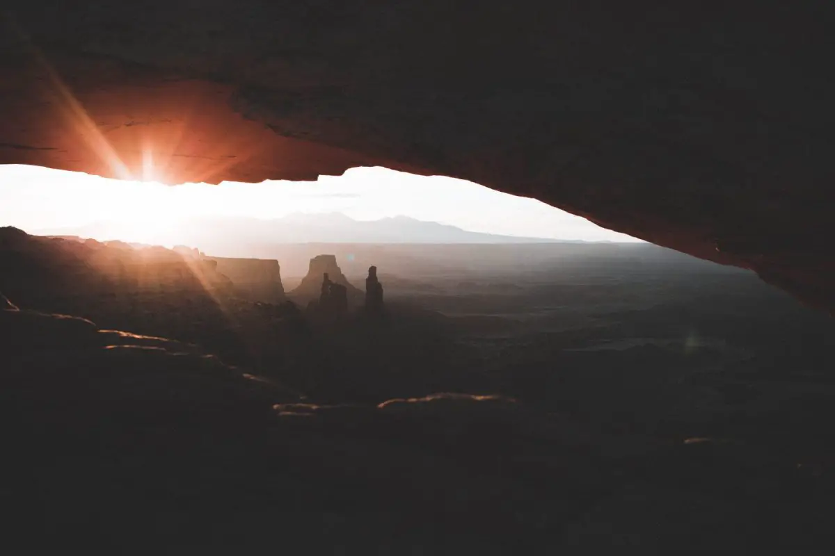
1 | Mesa Arch Trail
Quite possibly THE MOST iconic hike in Canyonlands is the Mesa Arch Trail. If you Google “canyonlands“, a picture of this view is always going to be the main selling point of this park, and rightfully so! Similarly to when I talked about the Delicate Arch being very hyped, the Mesa Arch is very much worth your time to go and see for sunrise. I experienced the arch at sunrise and I will argue with ANYONE that this is the best time to hike here. It will take your breath away!
As for the trail, it’s nothing difficult, long, or hard to navigate. It’s only a half-mile total, which makes it a quick and optimal sunrise mission! The trail is quick and to the point. If you are heading here for sunrise, there are always going to be other people here since it’s so easily accessible. If you want nice photos, you may want to get here a bit earlier to establish a spot. I had a run-in with some photographers here which you can read about here.
If you want a more expansive view, climb up the rocks on the left side and you’ll get to see the whole view without the arch!
TRAIL LENGTH | 0.5 miles round trip
DIFFICULTY | Easy
ELEVATION GAIN | 61 feet
TRAILHEAD LOCATION | Mesa Arch Trailhead
HIKING TIME | 15-30 minutes
2 | White Rim Overlook Trail
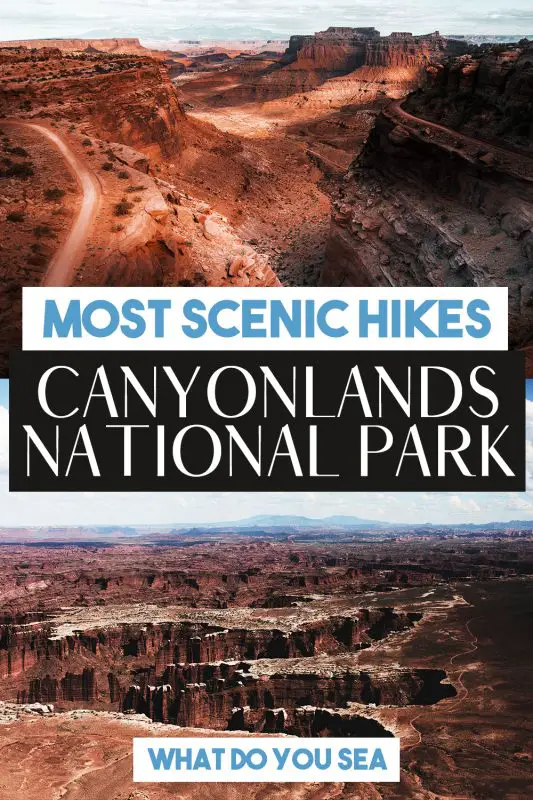
If you love a solid panoramic view, then the White Rim Overlook Trail is a MAGNIFICENT option if you want an easier hike in Canyonlands with an even more rewarding view. The main highlight of this trail is the very aptly named, “White Rim” that lines this section of Canyonlands National Park.
Not to be confused with the White Rim TRAIL, this hike is only 1.8 miles roundtrip and offers very little elevation gain, whereas the White Rim Trail is a 100-mile long scenic drive around the canyon rim. From the White Rim Overlook Trail, you’ll be able to watch the tiny Jeeps pass and get a good size comparison of just how massive this canyon is!
The trail begins at the Gooseberry Trailhead. You’ll see a picnic area and the trailhead is just beyond that. Once you arrive at the junction, you’re going to turn right and continue onto the overlook trail. If you go right, it will take you down the mesa and into Buck Canyon, so make sure you go left.
The trail starts out as gravel, but as you venture further, it gets more primitive and you’ll need to follow the cairns to get to the peninsula. Follow the trail until you cannot venture out anymore and enjoy the entire 300-degree view! Head back the way you came when you’re finished!
TRAIL LENGTH | 1.8 Miles round trip
DIFFICULTY | Easy
ELEVATION GAIN | 160 feet
TRAILHEAD LOCATION | White Rim Trailhead
HIKING TIME | ~1.5 Hours
3 | Gooseberry Trail
If you want more of a challenge when you get to the White Rim, the Gooseberry Trail takes you down the steepest route in Island in the Sky to the White Rim bench. You’ll be rewarded with up-close canyon views, distant mountains, and stunning vistas along the way.
What makes this trail difficult is the steep climb back up to the parking lot, but as long as you take it slow it will be more pleasant. Be sure to pack plenty of water and snacks, and aim to hike this trail in the morning since the hike out is more strenuous and will be in full sun by midday.
TRAIL LENGTH | 4.2 miles round trip
DIFFICULTY | Challenging
ELEVATION GAIN | 1,548 feet
TRAILHEAD LOCATION | White Rim Overlook
HIKING TIME | 3 hours
4 | Grand Viewpoint Trail
Similar to the White Rim Overlook Trail, the Grand Viewpoint Trail is another straightforward and simple hike if you’re looking for fantastic views with very little effort. This trail was a nice break before we set out to take on Bryce Canyon’s challenging hikes.
The trailhead for the Grand Viewpoint Trail is at the end of Grand View Road (so clever, I know lol). There is a solid view when you first arrive, but you’ll want to hike deeper down the trail for the panoramic view. Not that all of the hikes in Canyonlands aren’t panoramic anyway, but you get what I mean. The trail is 2-miles roundtrip and relatively flat for the duration of the hike.
The view you get isn’t so different from the view you start out with at the overlook, but the trek is definitely worth it for some nice photos overlooking Canyonlands National Park. If you’re looking for a good spot to watch the sunset, the Grand Viewpoint is excellent!
TRAIL LENGTH | 2 miles round trip
DIFFICULTY | Easy
ELEVATION GAIN | 173 feet
TRAILHEAD LOCATION | Grand View Trailhead
HIKING TIME | 1 hour
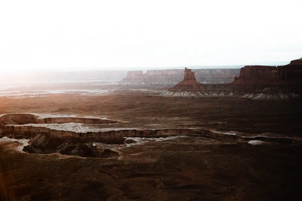
5 | Murphy Point Trail
Aside from the Mesa Arch Trail, the Murphy Point Trail was probably my next favorite hike in Canyonlands National Park. Since a lot of other trails are well-marketed for sunset and easier to get to, my friend and I had THIS WHOLE VIEW to ourselves for the last light over the canyon! The trail isn’t difficult by any means, and it basically just follows the canyon rim until it opens up to this beautiful view overlooking Candlestick Tower, the Green River, and the White Rim Road!
The trail to Murphy Point begins on some very soft and vibrant desert sand. You’ll walk through what feels like a rather expansive field and once you get closer to the canyon edge, you’ll see the amazing views come closer to the frame with each step! You can hike this trail for sunrise or sunset, but the vibes for sunset are too good to pass up, and if you only have one day in Canyonlands, then you’ll want to save sunrise for the Mesa Arch Trail, trust me.
TRAIL LENGTH | 3.6 Miles round trip
DIFFICULTY | Easy
ELEVATION GAIN | 147 feet
TRAILHEAD LOCATION | Murphy Point Trailhead
HIKING TIME | 1-2 Hours
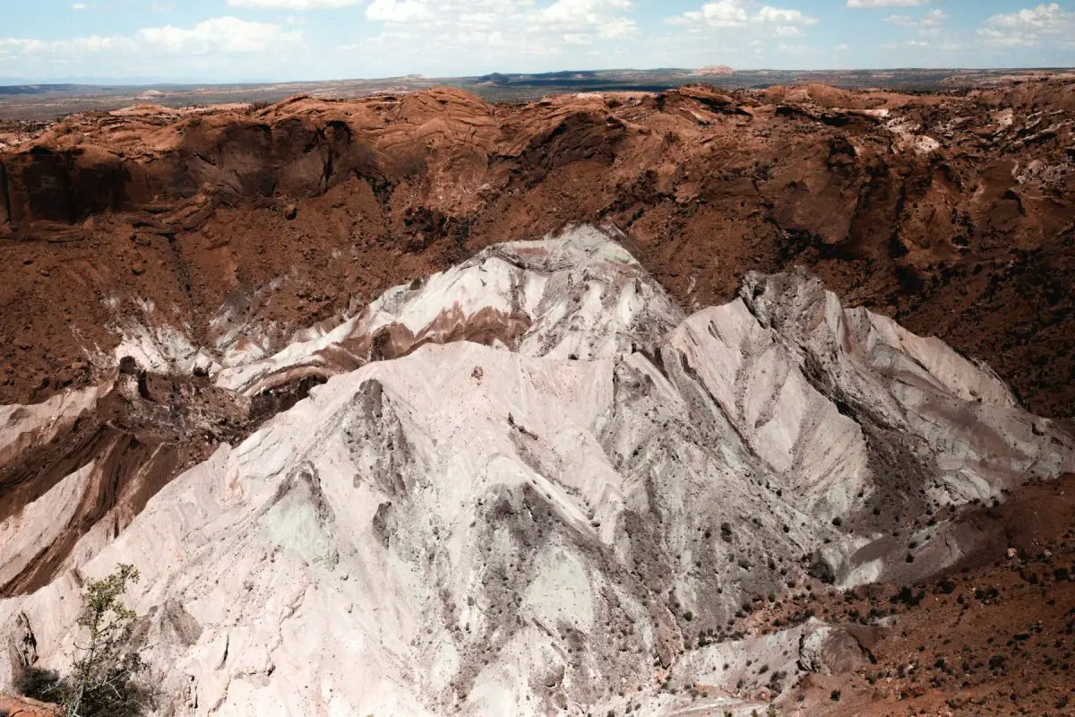
6 | Upheaval Dome Trail
Upheaval is one of the most interesting hikes in Canyonlands. What makes Upheaval Dome so interesting is that no one knows how this ominous rock was formed. There are current guesses as to how this rock formed: the Salt Dome Theory and the Impact Crater Theory.
Upheaval Dome is inside an expansive area of around three miles across where a rock formation protrudes out and these formations have not shifted since they first formed millions of years ago. The theory that is best supported is the Impact Crater Theory.
It states that a meteorite hit the earth roughly 60 million years ago which initially created an unstable crater that partially collapsed. Then, once the area reached an equilibrium, the rocks underneath heaved upwards to fill the area left on impact. Since then, erosion has carried away any remains of a meteorite and now gives a look at the parts of the crater that were once buried underground.
This spot is quite fascinating and the mystery behind this makes it all the wilder to look out on. I recommend adding the extra mile onto your hike and going to the second viewpoint since it gives a better view of the dome and you can see expansive views over Canyonlands on the left. If you only make it to the first overlook, it’s not as cool, in my opinion.
TRAIL LENGTH | 1-2 miles round trip (2 miles to the second overlook)
DIFFICULTY | Moderate
ELEVATION GAIN | 297 feet
TRAILHEAD LOCATION | Upheaval Dome Trailhead
HIKING TIME | 30-45 Minutes
MORE HELPFUL GUIDES FOR YOUR TRIP TO CANYONLANDS:
7 | Aztec Butte Trail
A lesser-populated hike, but still worthy of its spot on this list of the best hikes in Canyonlands is the Aztec Butte Trail. The highlights of this trail are Aztec granaries (storehouses) and of course the view from the top of the butte that overlooks the middle portion of the Island in the Sky.
The trailhead for Aztec Butte is down Upheaval Dome Road, just past the turn for the Willow Flat Campground. The trail starts on relatively flat, sandy ground that flows through juniper and sagebrush and around the first butte before you arrive at a junction. The trail to the left will take you to a pair of ruins on the northwest side of the butte, whereas the trail to the right leads up to Aztec Butte.
The climb up Aztec Butte is steep and challenging at certain points, but doable for most with a rewarding view at the top!
TRAIL LENGTH | 2 Miles round trip
DIFFICULTY | Moderate
ELEVATION GAIN | 211 feet
TRAILHEAD LOCATION | Aztec Butte Trailhead
HIKING TIME | ~1.5 Hours
8 | False Kiva Trail
One of the most underrated hikes in Canyonlands National Park is none other than the False Kiva Trail. Although this hike is short in length, it is strenuous and not maintained by the National Park Service, so while you’re exploring here, please make sure you bring plenty of water and download a copy of the trail either on AllTrails or the Hiking Project App.
Another thing to note is that the False Kiva Trail is a class II archaeological site, and while this is absolutely spectacular, vandalism has caused the alcove at the end of the trail to be closed. This is a very sacred site to the Native Tribes and any acts of vandalism is a federal offense, and disrespectful on all spectrums. Please respect the area while you’re here.
The trail does involve some light scrambling in areas, so keep your abilities in mind when choosing this spot.
TRAIL LENGTH | 1.9 miles round trip
DIFFICULTY | Moderate
ELEVATION GAIN | 449 feet
TRAILHEAD LOCATION | across the road from Alcove Spring Trail
HIKING TIME | 1 hour
9 | Whale Rock Trail
This is a short and sweet trail up a sandstone butte that has an expansive view of the Island in the Sky district, distant mountains, and spurs of the main canyon. This would be an ideal trail to stop and enjoy lunch since the walk up to the viewpoint is quick, so you can pack all your snacks and enjoy the view if the weather permits.
Whale Rock is alright compared to the other hikes in Canyonlands, but this is a good one if you have a family. Because this trail is short and sweet and takes under 30-minutes, it can easily be paired with other trails on this list.
TRAIL LENGTH | 0.8 miles round trip
DIFFICULTY | Easy
ELEVATION GAIN | 131 feet
TRAILHEAD LOCATION | Whale Rock Trailhead
HIKING TIME | 20-30 minutes
10 | Syncline Loop Trail
If you fell in love with the scenery in and around Upheaval Dome, the Syncline Loop Trail is an amazing loop that takes you through two canyons that surround the dome! The route around is well marked and a great way to escape crowds in the Island in the Sky. It’s recommended to go clockwise around this loop since you’ll beat some elevation and get a bit more shade in some areas.
If you want to add an additional two miles to this hike, you can take a stony streambed up to see panoramic views of Upheaval Dome. There is a small spur that is an out-and-back type of trail that is optional if you’re up for a bit of a detour. This trail is pretty secluded and strenuous in some places, but its the perfect challenge if you want views that not many people get to see!
TRAIL LENGTH | 8.6 miles
DIFFICULTY | Challenging
ELEVATION GAIN | 1,630 feet
TRAILHEAD LOCATION | Upheaval Dome Parking Area
HIKING TIME | 4-5 hours
Canyonlands National Park Day Hikes
Best hikes in the Needles
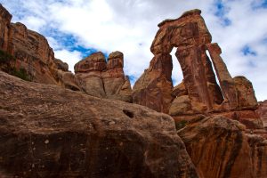
11 | Druid Arch Trail
NEEDLES DISTRICT
The Druid Arch is one of the two trails on this list that is located within the Needles District of Canyonlands National Park. Generally, the Needles District is an epic spot for overnight backpacking, so I couldn’t let this gem slip off the list, naturally!
To get to the Druid Arch, you’ll need to make a 10.8-mile out-and-back trail from the Elephant Hill trailhead. There are many different ways to get to the Druid Arch, but this is the route that’s most commonly used. Although it’s likely you won’t see many people on this trail anyway.
Cairns mark this primitive trail, so keep an eye out for those as you navigate through it. From the trailhead, you’ll hit a slot canyon and over a wash around 1.5 miles in, and from there you’ll hit a junction. Left goes to the Squaw Flat Campground and the right goes on the trail to Chesler Park. You’ll go right. There will be many junctions that you come across, but there will be signs to point you in the right direction.
I always recommend having some type of navigation with you so that you don’t get lost. Even something as simple as my favorite hiking app, The Hiking Project! (Most of the time) it will keep your GPS location even when you’re offline, so you can track the trail and junctions with ease.
There is excitement around every corner of this trail and the seclusion, exploration, and navigation you’ll need for this trail make it both a challenge and an amazing adventure! If you’re hiking during sunset, make sure you bring a headlamp since it can be easy to get lost here if you’re not paying attention.
TRAIL LENGTH | 10.8 miles round trip
DIFFICULTY | Challenging
ELEVATION GAIN | 1,374 feet
TRAILHEAD LOCATION | Elephant Hill Trailhead
HIKING TIME | ~5 hours
12 | Confluence Overlook Trail
NEEDLES DISTRICT
Hike along flat prairies, sandy wash bottoms, and vibrant sandstone on this stunning and remote trail to where the Green and Colorado Rivers confluence, or merge. It’s well-marked with cairns and is the perfect trail to get a slice of solitude. From the overlook, you’ll be able to look out to both the Island in the Sky and Maze districts from this point!
This is an amazing trail, but if you can only do one trail in the Needles, make it the next hike on this list, the Chesler Park Loop.
TRAIL LENGTH | 10.0 miles round trip
DIFFICULTY | Moderate
ELEVATION GAIN | 1,371 feet
TRAILHEAD LOCATION | Big Spring Canyon Overlook
HIKING TIME | 4-5 hours
13 | Chesler Park Loop Trail
NEEDLES DISTRICT
In the heart of Canyonlands National Park, Needle’s District is Chelser Park! This is an expansive grassy area surrounded by the iconic rock formations in this district. The park is a central area for a lot of the day hikes and overnight backpacking trips in this area!
This trail, like many others, begins at the Elephant Hill trailhead. The Chesler Park Loop is marked by cairns, small stacks of stones, to help you find your way so keep an eye out for those as you go along. The first mile or so takes you through magnificent rock formations in the Needles and will excite you for what lies ahead.
On this trail, you’ll see beautiful views over the Needles District, slot canyons, pinnacles, knobs, and more that will take your breath away! If you want to take this trail more slowly, consider making it a 2-day backpacking trip!
It’s very important that you bring plenty of water on this hike because it’s long and strenuous, and there is a chance you may get lost. As long as you watch for cairns you should be fine, but Canyonlands is incredibly remote and can be lethal if you’re not properly equipped.
TRAIL LENGTH | 10.4 miles round trip
DIFFICULTY | Challenging
ELEVATION GAIN | 1,820 feet
TRAILHEAD LOCATION | Elephant Hill Trailhead
HIKING TIME | 5-6 hours
Best hikes in Canyonlands Hiking Essentials
These day hiking essentials aren’t required to go hiking in Canyonlands, but they will make your experience much more comfortable! I have a guide for day hiking essentials to check out after this blog post to make sure you have all the proper gear!
– SUN PROTECTION | A lot of the hikes in Canyonlands are exposed, so you’ll need chapstick with SPF, a hat, and sunscreen.
– FIRST-AID KIT | Large or small accidents, you want to be covered. This lightweight first-aid kit fits nicely in my bag and has everything I need.
– WOOL SOCKS | Avoid cotton at all costs to prevent blisters. These are my favorite!
– GPS/NAVIGATION TOOL | This is crucial to keep you from getting lost. GAIA, All Trails, and Hiking Project are great apps to consider.
– WATER/SNACKS | Pack plenty of food and snacks for the day, as well as a hydration bladder or large water bottle, much more if visiting in the summer or hiking longer trails.
Best easy hikes in Canyonlands National Park:
Best moderate hikes in Canyonlands National Park:
Best difficult hikes in Canyonlands National Park:
– Chesler Park Loop Trail (Needles)
– Druid Arch Trail (Needles)
MORE HELPFUL GUIDES FOR YOUR TRIP TO CANYONLANDS:
– Packing For A Day Hike: 12 Adventure Essentials To Get You Exploring
– Canyonlands National Park in One Day: Ultimate Canyonlands Itinerary
ADD THESE CANYONLANDS HIKES TO THESE OTHER ROAD TRIP STOPS CLOSE BY:
– The ONLY Utah National Parks Road Trip Itinerary You Need
ZION NATIONAL PARK
– How To Conquer The Narrows Hike In Zion National Park (Complete Guide)
– 2 Days In Zion: The Ultimate Zion National Park 2 Day Itinerary
CAPITOL REEF NATIONAL PARK
– How To Spend One EPIC Day In Capitol Reef National Park
– Hiking The Cassidy Arch Trail In Capitol Reef National Park
BRYCE CANYON NATIONAL PARK
– The Ultimate Guide To Camping In Bryce Canyon National Park
– 10 Jaw-Dropping Bryce Canyon National Park Hikes You CANNOT Miss
– One Day In Bryce Canyon: The Perfect 1-Day Itinerary
ARCHES NATIONAL PARK
– A PERFECT 3-Day Itinerary For Arches National Park
– The BEST Guide To The Delicate Arch Hike In Arches National Park
– 10 Arches National Park Hikes That Will BLOW Your Mind
– The Ultimate Guide To Camping In Arches National Park
– Tower Arch Trail: The Best Hike In Arches National Park
WHAT IS YOUR MOST EMBARRASSING HIKING MEMORY? SHARE WITH ME IN THE COMMENTS BELOW!

DID YOU FIND THESE HIKES IN CANYONLANDS ADVENTURE-WORTHY? SAVE THEM FOR LATER!


Hi there. Would love advice on campervan camping in canyonlands. Thx!
Hi! Send me a message on Instagram @aarenprody and I’d love to help you out (:
Nice work.
Do note though:
You mention that Druid Arch is the only needles district hike on your list, but then immediately list another one in the district.
Hi! Thanks for catching this! It’s fixed (: